

Specifications

Description
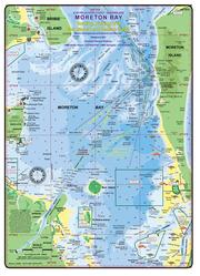
Queensland Boating, Fishing, Sea Search and Rescue Guide - resilient laminated waterproof chart - wrist lanyard - Size 22 x 31 cm - CAMTAS
Features
Features
- Water contours are shades of blue becoming progressively darker as depth increases
- Land contours become progressively darker as height increases
- Natural features, mangroves, sand types, mud, salt pans and others features are visually realistically depicted
- Grid reference system, latitude and longitude simplifies identifying positions for boating, fishing and rescue services
- Marine Emergency Search and Rescue contact details for Police and Volunteer Rescue Services are easily located on the chart
- Navigation marks and symbols are clearly indicated on the chart without the need for supplementary handbook
- Known information such as names, heights, depths, seabed, GPS marks, obstructions and navigational tracks included
- No fishing Zones, officially declared speed zones clearly indicated
- Lesser known information such as local knowledge of fishing and diving locations, local common names and information from latest satellite images are included at time of publication

Queensland Marine Safety Chart- Moreton Bay
Regular price
$20.00 AUD
Sale price
$20.00 AUD
Regular price
Unit price
per
