Online Shopping
- Accessories
- Books Commercial
- Books Recreational
- Boat Building, Repair & Maintenance
- Canoeing, Kayaking, Rowing
- Childrens Books
- Clymer Outboard Manuals
- Coffee Table Books
- Collectable /Limited Editions
- Cooking
- Cruising Guides
- Design
- Diving/Marine Life
- Electrics & Electronics
- Engines
- Fiction
- First Aid
- Fishing
- Fishing
- General Interest
- History
- History Australia
- History General
- History Liners
- History Naval
- Humour
- Knots
- Logbooks
- Marine Art
- Marine Stories
- Meteorology
- Modeling
- Navigation
- Power Boats
- Rigging
- RYA – Royal Yachting Association
- Sailing Basic
- Sailing Cruising General
- Sailing Multihull
- Sailing Racing
- Sailing Racing Rules
- Seamanship
- Tide Tables
- Yachting Australia
- Calendars
- Charts
- DVD & CD
- Fiction
- Gift Items
- Gift Vouchers
- Gift Wrapping
- Navigational Equipment
- NEW TITLES
- Online Training Courses
- Radio
- Sailing Watches
- Software
- Specials
- Uncategorized

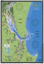
Queensland Marine Safety Chart – HERVEY BAY to NORTH REEF
$25.00 GST
HERVEY BAY to NORTH REEF
Boating, Fishing, Marine Safety Chart – Camtas publication MC610
BONUS WALL CHART – Complete Fishermans Guide Queensland and Great Barrier Reef reverse side
Size 61 x 88 cm
Features
Water contours are shades of blue becoming progressively darker as depth increases
Land contours become progressively darker as height increases
Natural features, reefs, mangroves, sand types, mud, salt pans and others features are visually realistically depicted
Grid reference system simplifies identifying positions for boating, fishing and rescue services
Marine Emergency Search and Rescue contact details for Police and Volunteer Rescue Services phone numbers including radio frequencies monitored are easily located on the chart
Navigation symbols are clearly explained on the chart without the need for supplementary handbook
Known information such as names, heights, depths, seabed, GPS marks, obstructions and navigational tracks included
Satellite positions derived from the WGS1984 datum can be plotted directly onto this chart
No fishing Zones, officially declared Smooth, Partially smooth, Open waters zones clearly indicated
Lesser known information such as local knowledge of fishing and diving locations, local common names and information from latest satellite images are included at time of publication
An affordable chart and perfect gift or reference guide both at home or on holidays
Related products
-
-
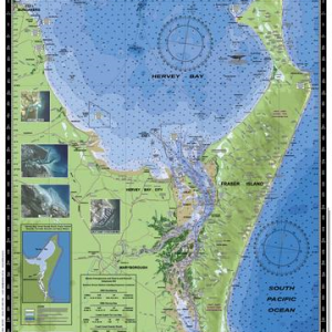 CAMTAS Charts
Queensland Marine Safety Chart- Fraser Island, Great Sandy Strait, Hervey Bay
$25.00 GST Add to cart -

Online Shopping
- Accessories
- Books Commercial
- Books Recreational
- Boat Building, Repair & Maintenance
- Canoeing, Kayaking, Rowing
- Childrens Books
- Clymer Outboard Manuals
- Coffee Table Books
- Collectable /Limited Editions
- Cooking
- Cruising Guides
- Design
- Diving/Marine Life
- Electrics & Electronics
- Engines
- Fiction
- First Aid
- Fishing
- Fishing
- General Interest
- History
- History Australia
- History General
- History Liners
- History Naval
- Humour
- Knots
- Logbooks
- Marine Art
- Marine Stories
- Meteorology
- Modeling
- Navigation
- Power Boats
- Rigging
- RYA – Royal Yachting Association
- Sailing Basic
- Sailing Cruising General
- Sailing Multihull
- Sailing Racing
- Sailing Racing Rules
- Seamanship
- Tide Tables
- Yachting Australia
- Calendars
- Charts
- DVD & CD
- Fiction
- Gift Items
- Gift Vouchers
- Gift Wrapping
- Navigational Equipment
- NEW TITLES
- Online Training Courses
- Radio
- Sailing Watches
- Software
- Specials
- Uncategorized