Online Shopping
- Accessories
- Books Commercial
- Books Recreational
- Boat Building, Repair & Maintenance
- Canoeing, Kayaking, Rowing
- Childrens Books
- Clymer Outboard Manuals
- Coffee Table Books
- Collectable /Limited Editions
- Cooking
- Cruising Guides
- Design
- Diving/Marine Life
- Electrics & Electronics
- Engines
- Fiction
- First Aid
- Fishing
- Fishing
- General Interest
- History
- History Australia
- History General
- History Liners
- History Naval
- Humour
- Knots
- Logbooks
- Marine Art
- Marine Stories
- Meteorology
- Modeling
- Navigation
- Power Boats
- Rigging
- RYA – Royal Yachting Association
- Sailing Basic
- Sailing Cruising General
- Sailing Multihull
- Sailing Racing
- Sailing Racing Rules
- Seamanship
- Tide Tables
- Yachting Australia
- Calendars
- Charts
- DVD & CD
- Fiction
- Gift Items
- Gift Vouchers
- Gift Wrapping
- Navigational Equipment
- NEW TITLES
- Online Training Courses
- Radio
- Sailing Watches
- Software
- Specials
- Uncategorized

New South Wales Boating, Fishing, Marine Safety Guide – Lake Macquarie
$20.00 GST
New South Wales Boating, Fishing, Sea Search and Rescue Guide – resilient laminated waterproof chart – wrist lanyard – Size 22 x 31cm – CAMTAS
Features
- Water contours are shades of blue becoming progressively darker as depth increases
- Land contours become progressively darker as height increases
- Natural features, mangroves, sand types, mud, salt pans and others features are visually realistically depicted
- Grid reference system simplifies identifying positions for boating, fishing and rescue services
- Marine Emergency Search and Rescue contact details for Police and Volunteer Rescue Services phone numbers including radio frequencies monitored are easily located on the chart
- Navigation symbols are clearly explained on the chart without the need for supplementary handbook
- Known information such as names, heights, depths, seabed, GPS marks, obstructions and navigational tracks included
- No fishing Zones, officially declared speed zones clearly indicated
- Lesser known information such as local knowledge of fishing and diving locations, local common names and information from latest satellite images are included at time of publication
Related products
-
 CAMTAS Charts
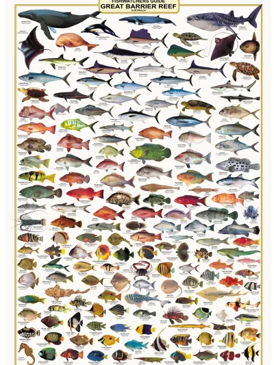
Fish Identification- Great Barrier Reef, Fishwatchers Species Wall Chart
$25.00 GST Add to cart -
-

Online Shopping
- Accessories
- Books Commercial
- Books Recreational
- Boat Building, Repair & Maintenance
- Canoeing, Kayaking, Rowing
- Childrens Books
- Clymer Outboard Manuals
- Coffee Table Books
- Collectable /Limited Editions
- Cooking
- Cruising Guides
- Design
- Diving/Marine Life
- Electrics & Electronics
- Engines
- Fiction
- First Aid
- Fishing
- Fishing
- General Interest
- History
- History Australia
- History General
- History Liners
- History Naval
- Humour
- Knots
- Logbooks
- Marine Art
- Marine Stories
- Meteorology
- Modeling
- Navigation
- Power Boats
- Rigging
- RYA – Royal Yachting Association
- Sailing Basic
- Sailing Cruising General
- Sailing Multihull
- Sailing Racing
- Sailing Racing Rules
- Seamanship
- Tide Tables
- Yachting Australia
- Calendars
- Charts
- DVD & CD
- Fiction
- Gift Items
- Gift Vouchers
- Gift Wrapping
- Navigational Equipment
- NEW TITLES
- Online Training Courses
- Radio
- Sailing Watches
- Software
- Specials
- Uncategorized